Regional 2D Line Merging for NDR
Creating basin-wide, aligned and merged 2D seismic layers for regional interpretation, regulatory readiness and cross-operator collaboration.
Explore the use case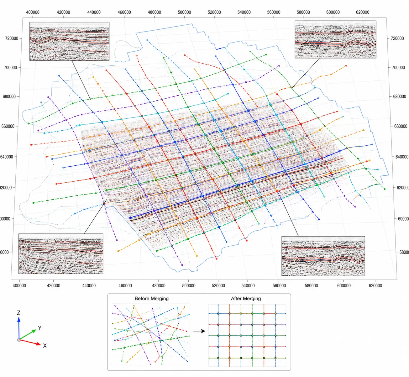
Fragmented seismic datasets make regional alignment and interpretation difficult.
Merging large 2D seismic datasets across basins is challenging because of varying coordinate systems, survey vintages and inconsistent data quality. Fragmented datasets hinder regional mapping, regulatory submissions and collaboration.
Inconsistent Coordinates
Different coordinate systems and projections make alignment across basins error-prone.
Overlapping Lines
Undocumented overlapping and intersecting seismic lines create spatial conflicts during interpretation.
Velocity Mismatches
Differences between velocity models create inconsistent depth references and stratigraphic ties.
Regulatory Delays
Extended quality-control cycles delay data readiness and ingestion into NDR platforms.
An integrated workflow for regional seismic line alignment and merging.
The SeisSense™ workflow aligns, harmonizes and consolidates 2D seismic data from multiple basins and survey vintages into a unified, regionally consistent layer.
Line Overlap Detection & Alignment
Detect spatial intersections and resolve line overlaps and mismatches across adjacent 2D seismic surveys.
Coordinate System Harmonization
Apply EPSG reprojections and datum transformations to bring survey data into consistent geospatial references.
Merged Velocity Model Construction
Blend velocity information from multiple vintages using regression fitting and structural ties for consistent depth references.
Output Consolidation
Deliver merged SEG-Y files, shapefiles and velocity overlays for interpretation platforms and regulatory systems.
From fragmented survey lines to a unified regional seismic layer.
The deployment brought together SEG-Y Rev 0 and Rev 1 datasets from multiple surveys, harmonizing geospatial references, overlaps and velocity information across basin areas.
Input Data
SEG-Y Rev 0 and Rev 1 datasets carrying varied EPSG codes and survey coordinate references.
Processing Scope
Overlap detection, line alignment, EPSG reprojection, datum transformation and velocity unification across survey vintages.
Final Output
Reprojected and merged SEG-Y datasets with aligned navigation, shapefiles and velocity overlays, ready for interpretation and regulatory use.
Basin-Wide Aligned 2D Seismic Layer
A harmonized seismic base for regional structural mapping, interpretation and national data repository workflows.
Regional seismic merging workflow at a glance.
Regional 2D SEG-Y Input
Load SEG-Y Rev 0 and Rev 1 surveys with their navigation and coordinate reference information.
Align & Harmonize
Detect overlaps, correct spatial mismatches, reproject coordinates and unify velocity references across vintages.
Merged Regional Output
Deliver merged SEG-Y files with aligned navigation, shapefiles and velocity overlays for interpretation and regulatory use.
Delivered through SeisSense™ Merge Tool, combining automated alignment logic and manual QC for efficient seismic line stitching and coordinate correction.
Building a consistent seismic foundation across basins.
The merged regional layer streamlines interpretation, accelerates regulatory readiness and supports collaboration using consistent, georeferenced seismic inputs.
Unified Regional Seismic Layer
Created a harmonized 2D dataset across basins and vintages, enabling regional structural mapping.
Faster Licensing Preparation
Reduced seismic data preparation time, accelerating readiness for regulatory submissions.
NDR-Compatible Output
Delivered merged layers suitable for integration into national data repository portals.
Cross-Operator Alignment
Established a consistent seismic base for multi-operator analysis and collaboration.
The 75% reduction in seismic data preparation time is the reported result stated in the source use case. Other benefits are described qualitatively.
SeisSense™
AI-powered seismic data processing, quality control and regional data harmonization for subsurface workflows.
Have a regional seismic data challenge to solve?
Let's explore how SeisSense™ can support your seismic data alignment and interpretation workflows.
Discuss this use case